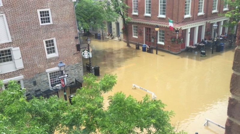
“Did you know that the spot where we are now used to be underwater?” blast the Alexandria Old Town Trolley’s speakers as we cross Lee Street, previously Water Street, heading towards the waterfront. In fact, on some days the area still fills up with water. On the building adjacent to the old Torpedo Factory, there are ruler markings reaching up to 12 feet that measure the water level on flood days.
This summer, there have been many mornings when I have had to make a detour to get into my office building due to Alexandria’s frequent inundation. I’ve even witnessed people casually having their lunch and coffee at sidewalk cafes as water from the river rose around them.

Alexandria built its waterfront below the river’s natural elevation. That’s become a real problem in recent years, and now the city is trying to figure out how to preserve its history and also adapt to a future with much more rain and flooding.
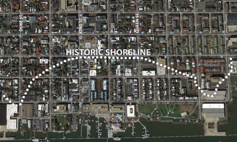
The Alexandria waterfront as we know it is actually a landfill that was created between 1749 and 1845. At the time, the constructed land was initially built at a lower elevation to increase waterfront acreage. That’s why recent heavy rainfall has caused the river water to rise and overflow onto the adjacent streetscape.
While some people mind the flooding more than others, climate change will likely increase the intensity and frequency and make it harder to manage.
These floods do not yet severely affect the infrastructure in the flood zone, but the city has a significant maintenance budget nonetheless, says Tony Gammon, Deputy Director at the Department of Project Implementation at Alexandria City. He says the money is mostly spent on removing debris and fixing occasional damage to street light poles. However, the city is also making much bigger changes.

Alexandria is installing a seawall to contain floods and high tides
Land now occupies where the old pier used to be. Up until recently, Alexandria’s Old Dominion Boat Club stood where the original Keyport to the city did, until a city initiative $5 million convinced it to relocate to The Strand area a couple of blocks south.
In a similar fashion, the city pushed developers to finalize ongoing projects in the area so that it could take flood mitigation measures. Among them: a continuous riverfront promenade that acts as a seawall and protects against rising waters, which the currently fragmented shoreline does not.
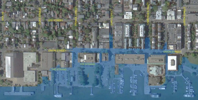
Alexandria’s flood mitigation project stretches from Duke to Queen streets, and aims to make the area more accessible and protect historic buildings. Targeted blocks’ promenade will be raised to six feet, an elevation ranging from one to four feet higher than the area around them. That six-foot elevation resolves the threat of a 10-year flood; that refers to the area that has a one in 10 chance of being flooded in any given year.
For comparison: the elevation for a 100-year flood is 10.2 feet and has a 1% probability of occurring in an area in any given year. That elevation much higher than the mean high tide at 1.4 feet. However, these “100-year floods” are becoming more common. In 2003, Hurricane Isabel caused the river to rise to 8.8 feet.
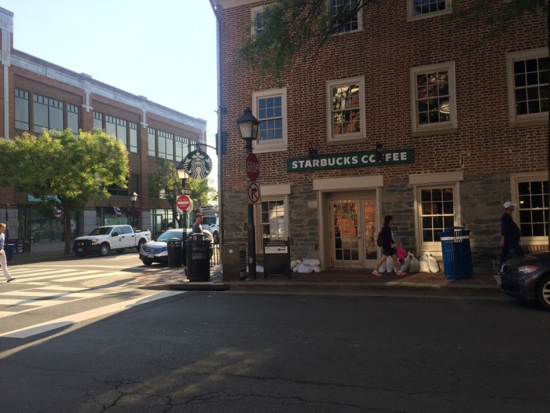
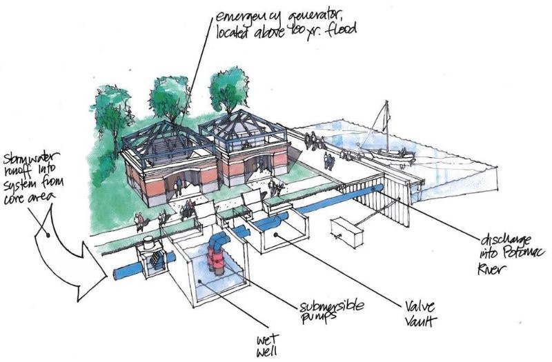
Al Cox, historic preservation manager at the Department of Zoning, says that 85% of nuisance flooding should be contained by this elevation increase. The seawall traps water and two pumps send it back into the Potomac. However, some historic buildings, such as the Starbucks and Chadwicks, cannot be raised. They currently use sandbags to keep the water from creeping in during heavy floods.
On a recent waterfront walking tour hosted by Coalition for Smarter Growth, Executive Director Stewart Schwartz and Development Division chief at the Alexandria Department of Zoning Robert Kerns both stressed that revitalizing inaccessible public spaces and smarter growth go hand in hand. They say that while other stormwater control measures such as green roofs, rain gardens, and bioretention should be taken when possible, they aren’t sufficient to deal with the amount of water that floods Alexandria’s below-grade river pier.
Planning for climate change — and tourists
Tony Gammon, who is responsible for the project, says that the primary challenge has been balancing aesthetics with a flood mitigation plan. “People have not been able to walk along the waterfront for a hundred years, with the privatization of the area and construction sites,” he says. Gammon hopes this project will not only protect the area, but also make the waterfront more usable for residents and visitors alike.
Alexandria is feeling competitive about its tourism, especially now that the Wharf in DC has opened. Tourists often get to the waterfront and ask where the water actually is. When the area is flooded, the tourist trolley doesn’t even reach the waterfront, but rather stops at city hall two blocks away. Despite the barricades Alexandria police place to protect them from flooding and a sign directing them to another stop, I have often seen tourists patiently waiting for the trolley to pick them up.

The city created an interim “King Street Park,” a decision made in collaboration with a waterfront commission representing area civic groups. They’re putting up signs and making the area more pedestrian-friendly. Construction is expected to be finalized at the end of September 2018. Tellingly, work was halted for more than 20 days since it began last April due to flash floods.
I asked Gammon about any risks as the water level rises, inundates the site, and recedes again. He says the project site is currently at the lowest grade along the waterfront, but the city would not build a conventional retaining wall because it would block the view and taint the historic value of Old Town. The city has a sedimentation control plan in effect, and in a high tide stage, the flood water drains through erosion control measures back into the river.

What’s next for Old Town
The overall project is expected to happen in phases, with the shoreline construction happening first. While details are not yet final, city officials hope to keep as much of the area as possible open to the public during construction.
Some long-time residents are complaining that “this is not Disneyland” and say the city is wasting taxpayer money on making Old Town an “artificial” tourist spot. However, the project’s updates not only mitigate the impacts of climate change, but also improve the street grid and better connect parts of the city to its waterfront.
The new waterfront plan aims to preserve the area’s history, reclaim its parks and make them more usable for more people, and to mitigate the impacts of floods. That’s all essential for Alexandria’s growth into the future.
